The Kari Motor Speedway is a prominent racetrack in South India, known for hosting major domestic and international motorsport events and training professional racers.
Before SKYX Aerospace’s involvement, the Kari Motor Speedway faced a significant challenge in documenting track changes for approvals.
SKYX Aerospace deployed its drone survey team at the racetrack for two days, covering an area of over 50 acres. The captured data was then processed within the next two days, ensuring a fast and efficient turnaround.
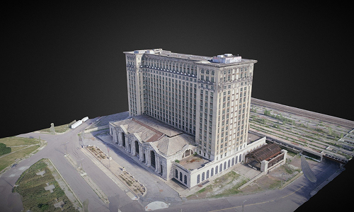
High-resolution aerial image with a Ground Sampling Distance of less than 3cm, allowing precise inspection down to 3cm objects.
Provided detailed insights into track elevation, corner inclines, and elevation shifts.
Includes Start/Finish Line, Pit Lane, Marshal Posts, Exits, Corners, and more.
Enables remote visualization with detailed data layers in Google Earth Pro, enabling users to click on labels and view additional details.
Delivered for VR simulations, driver training, and marketing animations.
By leveraging SKYX Aerospace’s drone technology, the Kari Motor Speedway has revolutionized its documentation process, improved operational efficiency, and enhanced the overall experience for both stakeholders and racing professionals.
Interested in transforming your facility with drone-based mapping and digitization? Get in touch with us today!
©2025 SKYX AEROSPACE PVT. LTD.