CONSTRUCTION

KEY INDUSTRIES

Enlift construction with survey and lifting solutions for your sites!

Swift surveys. Frequent asset inspections. Reliable consistency. Lower labor costs. Enhanced efficiency. Maximized profitability with construction drones.

SKYX KISAAN

Key Benefits

Time

Using Drones will reduce the time by 70-80%

Cost

Using drones will reduce the costs overall

Accuracy

Drones data can produce data with such high accuracy

Outputs

More Outputs possible in a fraction of the time

Comparative Analysis

Comparison Between Old Vs New Age

Time

Highly Time Consuming

Outputs

Less Accurate Outputs

Digital

Non availability of
Native Digital Data

Human Health Effects

More man power for Big Projects

Very fast

Very fast

Accuracy

Highly accurate outputs

Digital Asset

All Assets are Digitized

Drone Capacity

Maximum of 2 people per drone

PROVEN ADVANTAGES

Concrete benefits, enhanced efficiency, cost savings, improved safety, and streamlined operations in construction.

Extended Flight
Time

Continuous operation enabled without landing for recharging, extending the drone's operational span.

Continuous Power Supply

Ideal for uninterrupted operations like surveillance, monitoring, or live broadcasting applications.

Secure Data Transmission

Safely transmits real-time data via tie for secure, low-latency connections in various applications.

Cost-Effective Operations

Tethered drones offer continuous services, eliminating the need for multiple drones in succession.

Reduced Logistical Challenges

Tethered drones soar continuously, streamlining ops & minimizing logistical challenges for best outcomes

Adaptable
Applications

Tethered drones excel in urban surveillance and disaster response, thriving in challenging conditions.

SKYX DRONE APPLICATIONS

SKYX Drone Applications

Advanced drone technology is transforming the construction and infrastructure sectors by providing highly accurate aerial data, real-time monitoring, and intelligent decision-making capabilities. SKYX Drone as a Service (DaaS) offers aerial site surveys, topographic mapping, and remote project monitoring, streamlining operations while improving efficiency, safety, and cost-effectiveness.

Key Benefits & Features
  • Aerial Site Surveys, Capture precise data and high-quality imagery using advanced drones.
  • Topographic Mapping, Generate accurate elevation and land contour information.
  • Real-Time Progress Monitoring, Track work progress and identify deviations from plans.
  • Earthwork Management, Optimize material usage and ensure proper site grading.
  • Enhanced Safety, Conduct inspections, identify hazards, and promote a safer work environment.
  • 3D Modeling, Visualize the final project outcome and detect design clashes.
  • Environmental Assessment, Evaluate the project’s environmental impact and implement mitigation strategies.
  • Data-Driven Decisions, Analyze data to optimize resource allocation and streamline operations.
  • Quality Control & Inspections, Ensure adherence to construction standards and identify defects promptly.
  • Automated Documentation, Simplify data collection and reporting processes.
  • Project Archives, Maintain a digital record of project history for future reference.
  • Cost Savings, Reduce reliance on manual methods, leading to cost-efficiency.
  • Improved Communication, Facilitate project visualization and collaboration among stakeholders.
  •  

SKYX Disaster Relief

In times of crisis, speed, accuracy, and coordination are essential for effective disaster response. SKYX Drones offer real-time aerial assessment, search and rescue assistance, damage evaluation, and emergency supply delivery, significantly enhancing disaster relief efforts. These autonomous, high-tech drones provide rapid situational awareness, support communication restoration, and ensure efficient deployment of resources to minimize damage and save lives.

Key Benefits & Features
  • Rapid Damage Assessment, High-resolution data captured by drones provides immediate insights into the situation.
  • Search & Rescue, Drones help locate survivors and hazards in large areas, including hard-to-reach locations.
  • Detailed Damage Mapping, Create comprehensive maps to direct resources to critical areas.
  • Communication Restoration, Drones with relay capabilities help re-establish lost communication infrastructure.
  • Delivery of Essential Supplies, Drones deliver medical aid, food, and water to inaccessible regions.
  • Enhanced Security, Monitor affected areas to deter looting and ensure safety.
  • Post-Disaster Planning, Data facilitates reconstruction efforts and long-term recovery plans.
  • Seamless Integration, Collaborate with emergency services for a coordinated response.

SKYX Rescue and Surveillance Sector

SKYX Drones redefine rescue, surveillance, and emergency response by providing high-resolution aerial data, real-time intelligence, and enhanced situational awareness. These advanced UAVs (Unmanned Aerial Vehicles) offer faster damage assessment, search & rescue assistance, security monitoring, and precision deliveries in both emergency and routine operations.

With rapid deployment, remote sensing capabilities, and AI-powered analytics, SKYX Drones help authorities, first responders, and security teams make data-driven decisions that enhance public safety, disaster response, and infrastructure security.

Key Benefits & Features
  • Rapid Response & Assessment: Deploy swiftly for immediate aerial insights in emergencies.
  • Enhanced Search & Rescue: Cover large areas quickly, locate survivors in hard-to-reach locations.
  • Improved Damage Assessment: Create detailed aerial maps to prioritize relief efforts.
  • Communication & Security: Re-establish communication infrastructure, monitor for safety.
  • Precision Delivery: Deliver critical supplies to disaster zones inaccessible by traditional means.
  • Data-Driven Decisions: Gather real-time information to optimize traffic flow, enforce regulations, and improve public safety.

SKYX Traffic Management

SKYX Drones redefine traffic monitoring, incident management, and infrastructure inspection by offering real-time aerial intelligence, high-resolution surveillance, and advanced data analytics. Equipped with cutting-edge sensors and AI-driven analytics, these drones provide instant situational awareness, enabling authorities to optimize traffic flow, enhance road safety, and improve urban mobility.

With their ability to monitor congestion, detect violations, assess environmental impact, and support emergency response, SKYX Drones contribute to smarter cities and more efficient transportation systems.

Key Benefits & Features
  • Real-Time Traffic View: High-resolution cameras and sensors provide instant insights into congestion, accidents, and road conditions.
  • Enhanced Incident Management: Rapid response to accidents and road closures facilitates quicker decision-making for rerouting and dispatching aid.
  • Event Traffic Support: Monitor parking areas, assess crowd flow, and implement control measures for smooth traffic flow during large gatherings.
  • Proactive Infrastructure Inspection: Regular aerial inspections of bridges, tunnels, and highways identify potential maintenance needs to prevent disruptions.
  • Public Safety & Law Enforcement: Monitor traffic for violations, gather evidence, and promote safer driving behavior.
  • Environmental Monitoring: Assess traffic-related pollution to support eco-friendly transportation initiatives.
  • Emergency Response Assistance: Evaluate road conditions, identify critical areas, and aid in coordinating evacuation routes during emergencies.
  • Data-Driven Strategies: Traffic data empowers authorities to make informed decisions for optimized traffic signals and improved management strategies.
  • Seamless Integration: Integrates with existing systems to provide a comprehensive view for better decision-making.

SKYX Crowd Monitoring

SKYX Drones revolutionize crowd surveillance, security, and event management by providing real-time situational awareness, data-driven decision-making, and enhanced communication tools. These drones offer unmatched aerial visibility, allowing event organizers, security teams, and emergency responders to proactively manage large gatherings, improve public safety, and optimize event logistics.

Equipped with high-resolution cameras, AI-driven analytics, and integrated speaker systems, SKYX Drones enable efficient crowd control, rapid emergency response, and seamless post-event analysis, ensuring a safer, more organized, and enjoyable experience for attendees.

Key Benefits & Features
  • Real-Time Crowd Monitoring: High-resolution cameras provide a bird’s-eye view for monitoring crowd density, movement, and potential issues.
  • Enhanced Situational Awareness: Offer a comprehensive view of the entire venue, allowing for proactive management of crowd flow.
  • Informed Emergency Response: Provide crucial insights into crowd behavior for planning, resource allocation, and swift response during emergencies.
  • Direct Communication: Speaker system enables real-time announcements, instructions, and information dissemination for crowd control and public safety.
  • Dynamic Crowd Management: Data analysis allows for adapting crowd control measures based on real-time situations, preventing congestion.
  • Proactive Security Measures: Identify potential security breaches, monitor unauthorized access, and provide a wider view for security personnel.
  • Improved Attendee Experience: Facilitate clear communication through announcements and updates, enhancing overall satisfaction.
  • Post-Event Evaluation: Data analysis helps assess crowd behavior, evaluate management strategies, and improve future event planning.
  • Seamless Integration: Integrates with existing event management systems for a unified approach to crowd control.
  • Public Safety Focus: Contributes to a safer event environment by enabling effective monitoring, communication, and emergency response.
Core Services

Primary Services Offered By SKYX

Skyx offers drone services for aerial surveys, mapping, data collection, and inspections, providing efficient solutions for industries like construction and agriculture.

Site Survey

Deviation Detection

Progress Monitoring

Site Inspections

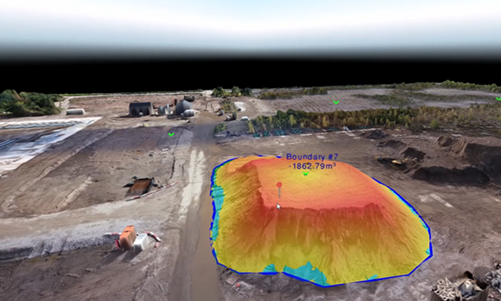
Earthwork & Stockpile Estimates

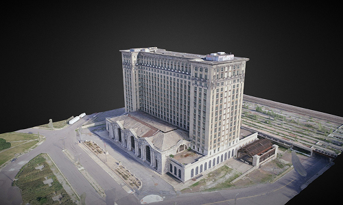
3d Modelling Of Sites And Buildings

Deliverables To Our Clients

2D Orthomosaic

High quality 2D Orthomosaic Maps with a least precision of 4cm/px for latest site updates

3D Sparse and Dense Cloud

Point cloud data can be used for creating landscaping and building new models upon

Elevation Models With Contours

Elevation models with contours can be used to analyze the water flow patterns to plan the pipeline

3D Textured Models

3D Models can be used for Inspection of unreachable places and to showcase the progress

2D and 3D Kml Files

Can be shared to the stakeholders to see the realtime update directly from google earth

Visual Highlights

Showcasing Our Finest Moments

Explore our comprehensive image gallery showcasing advanced site mapping and surveying techniques. From high-quality orthomosaic images and topographic surveys to 3D building modeling and volumetric analysis, see how drone technology enhances traditional methods for accurate progress monitoring and deviation detection.

Get in Touch

Get in Touch With Us

Whether you have inquiries, seek collaborations, or just want to explore the possibilities, we’re here for you. Connect with SkyX!