

Increased
safety
Improve safety to minimize human exposure to danger and enable remote inspection of hazardous zones.

Improved
efficiency
Streamline data collection for faster, precise surveying, mapping, logistics, and transportation.

Reduced
costs
Cut costs, save time and money vs. traditional methods, minimizing equipment damage and accidents.

Enhanced Data Integration
Drones facilitate the integration of various cutting-edge technologies such as AI, IoT, and advanced sensors.

Real-time Decision Support
Enhances efficiency and enables rapid responses, minimizing disruptions amid changing conditions.

Customizable
Solutions
Drones provide adaptable platforms for customized business applications as per unique requirements.


Aerial Surveying
Efficient topographic mapping and 3D modeling of mining sites.
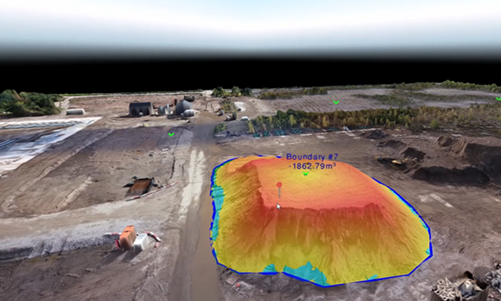
Stockpile Monitoring
Accurate volume measurements and inventory management.

Depth Calculation
Determining the depth of mining excavations.

Surveillance
Security and operational
monitoring.


SKYX CARTER M-24
Survey and mapping drone with high-resolution imaging and extended endurance for efficient data collection and mapping

SKYX CARTER 30x
Advanced Day time surveillance and nspection drone with powerful capabilities for enhanced security and thorough aerial inspections.

SKYX CARTER T-640
Enhances mining safety by detecting temperature variations, identifying potential hazards, and Night time Surveillance