


SKYX CARTER
M-24

SKYX CARTER
30x

SKYX CARTER
T-640
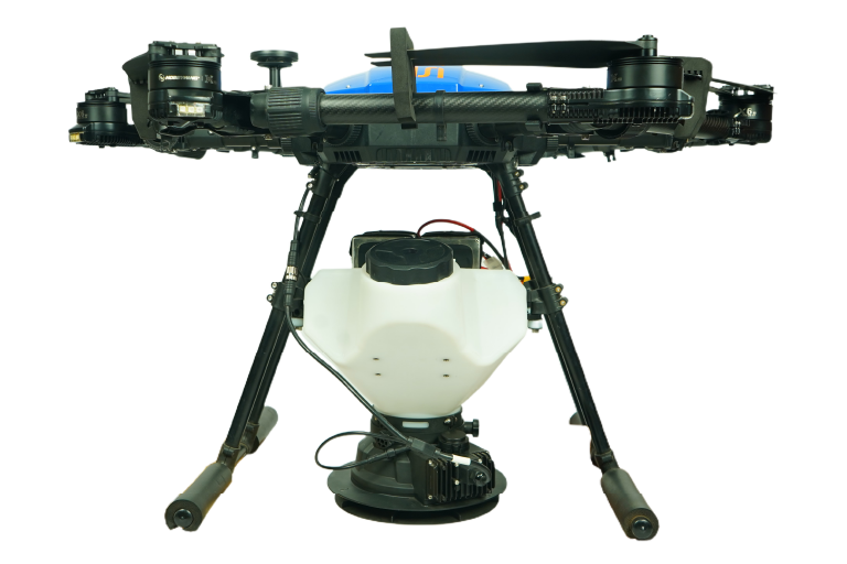
SKYX CARTER
FORESTER

3D
MODELLING
For environmental assessment, 3D models help detect water logging and analyze soil erosion.

REFORESTATION PLANNING
Prioritize detailed data in reforestation planning, vital for environmental restoration.

SOIL HEALTH
ANALYSIS
For comprehensive soil health monitoring, it is crucial to have precise biometric data available.

ILLEGAL LOGGING DETECTION
In vast areas, drones are used to detect illegal logging, which is a valuable resource.

IMPROVED FOREST MANAGEMENT
Boost forest management with drones, monitoring vegetation health for better assessments.

FIRE
PREVENTION
Thermal imaging drones detect fire risks early, enabling swift responses to prevent disasters.


Forest Mapping
Drones enable efficient forest mapping with high-resolution aerial imaging, capturing detailed topographical and vegetation data. This enhances precision in resource management and conservation planning.

3D Modelling for Water Logging Detection and Soil Erosion Analysis
Cameras capture forest canopy images, creating digital elevation models (DEMs) and 3D maps to analyze waterlogged soil and monitor erosion trends over time. These models help track soil loss and erosion patterns.

Reforestation Planning
Provides a bird's-eye view for comprehensive forest monitoring for aiding in identifying deforested areas, and facilitating precision reforestation planning through real-time data on vegetation density and land conditions.


Wildlife Monitoring
Offers a non-intrusive approach to monitor and protect endangered species. From tracking animal movements to preventing poaching. They provide crucial data for minimizing human disturbance and maximizing the wildlife protection initiatives.

Monitoring Illegal Logging
Acts as vigilant guardians of our forests, patrolling vast areas with aerial surveillance to detect logging activities. Real-time monitoring allows authorities to respond swiftly, preserving ecosystems and safeguarding against unauthorized tree felling.


Night Time Surveillance and Habitat Monitoring
Advanced imaging with infrared and low-light cameras enables nighttime surveillance, capturing high-resolution and thermal data. Silent flight ensures non-intrusive observations of elusive species and ecosystems.

Forest Fire Detection
Provides a bird's-eye view for comprehensive forest monitoring, supporting in identifying forest fires with their respective hotspots with Temperatures at utmost accuracy.
Soil Health Analysis
Provides a bird's-eye view for comprehensive Soil monitoring by capturing images of the soil surface in different wavelengths of light. These help in revealing the variations in soil temperature, moisture content, and other important indicators of soil health.

Firefighting Ball & Seedball Dispensing
Can revolutionize reforestation efforts by dispersing seedballs across vast areas with pinpoint accuracy, promoting biodiversity and restoring ecosystems from the skies.

Disease And Pest Control
Equipped with advanced sensors and targeted spraying capabilities offer a proactive and efficient approach to protection, enabling combat diseases and pests precisely, reducing environmental impact.


Forest Mapping
Efficient forest mapping using high-resolution aerial imaging enables detailed topographical and vegetation analysis. This ensures accurate assessment for resource management and conservation planning.

3D Modelling
Camera images of the forest canopy create digital elevation models (DEMs) and 3D maps, identifying waterlogged soil and erosion patterns. These models help monitor soil loss and erosion trends over time.
Reforestation Planning
Provides a bird's-eye view for comprehensive forest monitoring for aiding in identifying deforested areas, and facilitating precision reforestation planning through real-time data on vegetation density and land conditions
Soil Health Analysis
Provides a bird's-eye view for comprehensive Soil monitoring by capturing images of the soil surface in different wavelengths of light. These help in revealing the variations in soil temperature, moisture content, and other important indicators of soil health.